


Table of Contents
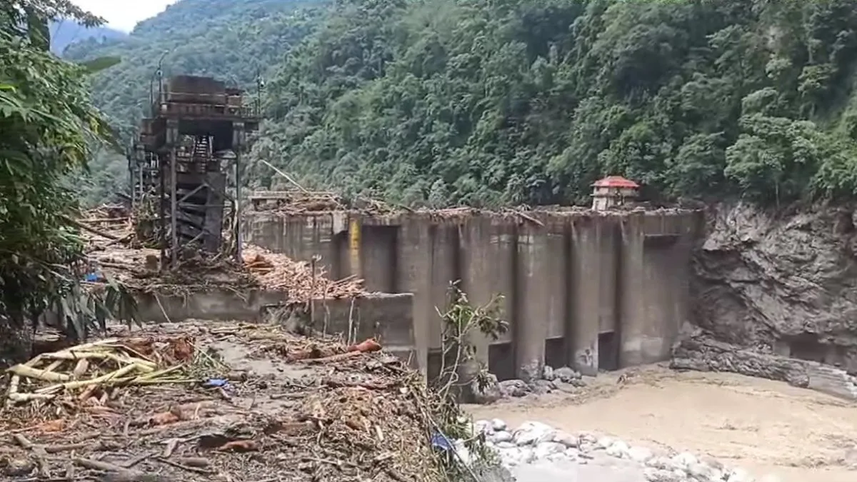
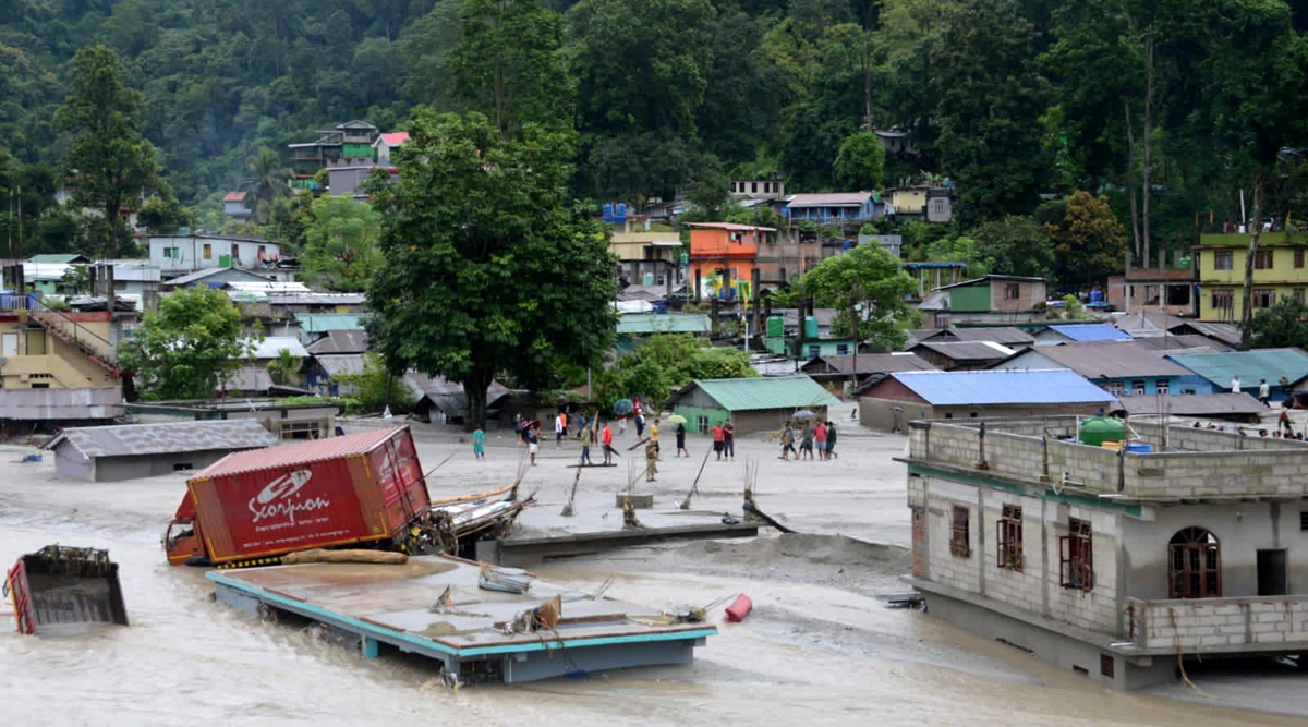
A flash flood in North Sikkim on October 4 resulted in the destruction of Sikkim’s largest hydropower venture, the 1,200-MW Teesta III project. This led to further damage downstream in areas including Gangtok, Namchi, and Pakyong. The latest update from the Sikkim State Disaster Management Authority on October 8 reported 33 fatalities and 105 individuals still unaccounted for.
The destruction of the Teesta-III project’s dam and the impairment of the Teesta-V dam due to the flood have refocused attention on the series of hydel projects, both existing and planned, along one of the most dammed rivers in the nation.
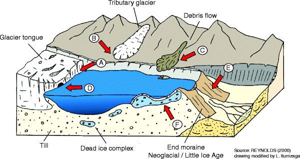
The Sikkim chief minister’s office has labelled the event an “unexpected natural calamity”. The National Disaster Management Authority attributed the sudden surge to a combination of excessive rainfall and a glacial lake outburst flood (GLOF) at the South Lhonak glacial lake. GLOFs occur when lakes formed by melting glaciers exceed their capacity, often due to heavy rainfall or the natural erosion of their embankments following landslides or earthquakes.
The opposition party in Sikkim, the SDF, has called for a comprehensive investigation into the dam failure by federal authorities. This request comes after Chief Minister Prem Singh Tamang attributed the rupture of the Teesta-III dam to its “inferior construction.”
What is Glacier Lake Outburst Flood (GLOF)
Glacier Lake Outburst Floods (GLOFs) occur when large lakes, formed by the melting of glaciers, suddenly break free from their natural dams made of rock, sediment, and debris, known as moraines. The South Lhonak glacier in northern Sikkim, one of the fastest retreating glaciers, has receded almost 2 km between 1962 and 2008, and an additional ~400 m from 2008 to 2019.

The Himalayas are home to roughly 7,500 glaciers, and GLOFs have been linked to significant disasters over the years. Meanwhile, Sikkim has 694 glacial lakes, with South Lhonak, situated at an elevation of 5,200 meters, identified in a 2021 study as one of 21 lakes posing a potentially high risk of outburst.
According to a study in the journal Nature, events like the 1926 Jammu and Kashmir deluge, the 1981 Kinnaur valley floods in Himachal Pradesh, and the 2013 Kedarnath outburst in Uttarakhand are all examples of disasters associated with GLOFs. Among the Indian Himalayan states, Sikkim has the highest number of glaciers, around 80, surpassing any other state. Climatologists have long cautioned that these glaciers could pose a risk for lake outbursts.
Dam Construction in Sikkim
Local activists and environmental experts highlight that the glacial lake outburst flood’s impact was worsened by the presence of multiple dams along the Teesta river basin. The flood originating from the lake not only damaged its structures but also led to the destruction of three downstream dams, releasing the water from their reservoirs and exacerbating the flooding and devastation.

Activists assert that they had previously cautioned authorities about the risks of constructing dams in an earthquake-prone area like Sikkim. A 2020 report from the National Disaster Management Authority, while assessing potentially hazardous lakes in the Himalayan region, specifically noted that the “risk to hydropower is highest in Sikkim.” It was known by the government that the dams on the Teesta river were vulnerable due to the South Lhonak lake.
Mayalmit Lepcha, a member of the local advocacy group “Affected Citizens of Teesta” and a resident of Dzongu, stated that they had been expressing our concerns for a long time about the construction of a series of dams along the Teesta. They said that the Teesta III had already stored a significant amount of water in its reservoir, so when the flash flood occurred, it came down with much greater force.
An official from the Central Water Commission admitted that the dams had amplified the damage in this situation, explaining, “If there is a series of dams, a cascading effect occurs downstream during flash flood scenarios.”
According to officials, there was an emphasis on the necessity for more effective monitoring of glacial lakes to avert future disasters. However, environmental experts, including Amitangshu Acharya, a lecturer at the Netherlands-based IHE Delft, an institute for water education, who has dedicated four years to working on water governance in Sikkim, asserted that the insights run deeper. Acharya pointed out that there is knowledge of tectonic activity in the Himalayan region, the significant silt content carried by the rivers, and the historical occurrence of cloud bursts.
Acharya stated that the government is cognizant of these uncertainties. He questioned, “Why were dams constructed, effectively creating potential hazards on the riverbed?” He expressed, “These are time bombs waiting to go off.”
Read Further: https://inpactimes.com/imf-and-world-bank-conduct-meetings-for-the-first-time-in-5-decades-in-africa/


